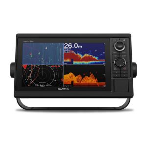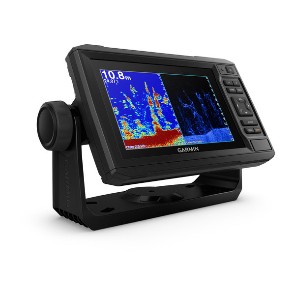


Description
- Bright, sunlight-readable 6” combo
- Includes transducer for Garmin CHIRP traditional sonar plus CHIRP ClearVü™ scanning sonar with transom and trolling motor mounts
- Preloaded Canada LakeVü HD maps cover more than 13,500 lakes, of which more than 4,800 are HD lakes with 1’ contours
- Built-in Garmin Quickdraw™ Contours mapping software instantly creates personalized fishing maps on-screen with 1’ contours as you fish
- Use built-in Wi-Fi® to pair with the free ActiveCaptain® for access to OneChart™, smart notifications¹, Garmin Quickdraw™ Community data and more
- Share waypoints and routes with other ECHOMAP™ or STRIKER™ units

Bright, sunlight-readable 6” combo includes one transducer that features both Garmin CHIRP traditional sonar and CHIRP ClearVü scanning sonar. Preloaded with Canada LakeVü HD maps cover more than 13,500 lakes, of which more than 4,800 are HD lakes with 1’ contours. Plus, Quickdraw Contours mapping software to instantly create personalized fishing maps on-screen with 1’ contours as you fish. It also has built-in Wi-Fi® to pair with the free ActiveCaptain app for access to OneChart, which allows you to purchase and download new charts. ActiveCaptain also gives you access to smart notifications1, the ActiveCaptain community for marina and other points of interest details, Quickdraw Community data and more. You can also share waypoints and routes with other ECHOMAP or STRIKER units. Features quick-release bail mount to make it easy to remove and take with you. Transom and trolling motor mounts included.
The Garmin CHIRP Difference
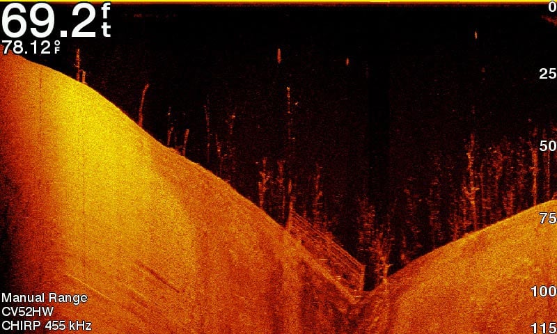
The built-in sonar capabilities of ECHOMAP Plus 65cv include our CHIRP traditional sonar, one of the most sophisticated sonar technologies available for the fishing and boating public. CHIRP traditional sonar provides amazingly clear target separation and definition, because it puts even more energy onto the target than traditional sonar. It also provides traditional sonar support for Minn Kota® and MotorGuide®trolling motors with integrated transducers.
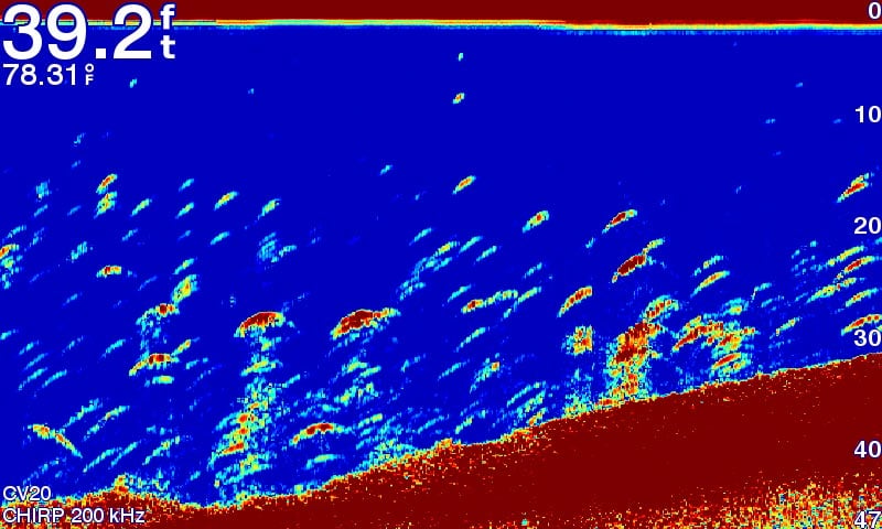
Clear Scanning Sonar Images
Garmin CHIRP ClearVü scanning sonar gives you a nearly photographic, wide image of what passes below your boat. You clearly see structure, submerged objects and fish. Garmin CHIRP traditional sonar and ClearVü scanning sonar are combined into 1 transducer.
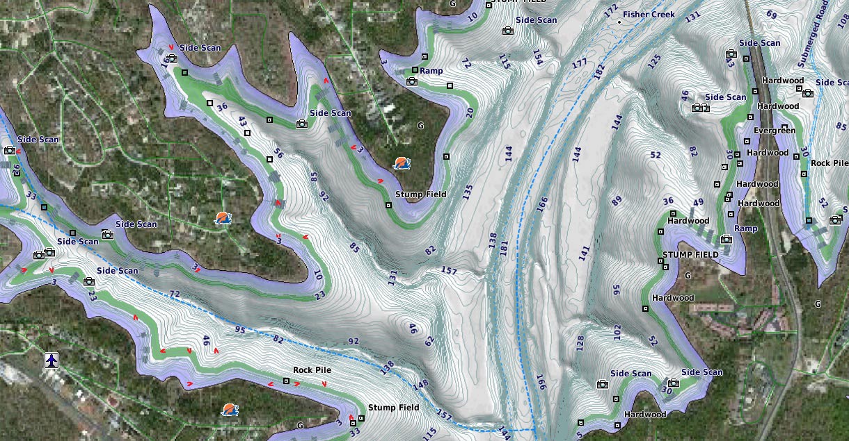
Preloaded Canada LakeVü HD Maps
These highly detailed freshwater maps include 13,500 Canada lakes, rivers and reservoirs, including coverage for the Great Lakes and Trent Severn Waterway. That number also includes more than 4,800 HD lakes with 1’ contours in Alberta, British Columbia, Nova Scotia, Ontario, Quebec, Saskatchewan and Yukon provinces. Canada LakeVü HD gives you excellent detail of underwater features, plus Shallow Water Shading allows you to designate a minimum depth. It also shows interstates, general roads and bridges, designated fishing areas, boat ramps, marinas and campgrounds.
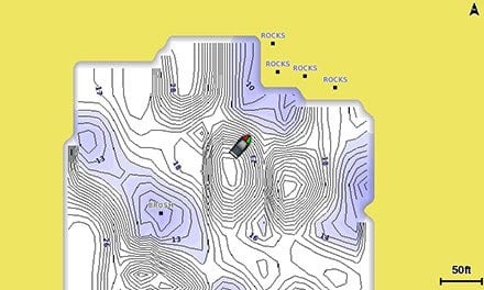
Quickdraw Contours to Create Your Own Maps
Instantly create personalized fishing maps on-screen with 1’ contours. Tailor them to fit your needs. These are your maps — you own them. Keep the data to yourself, or share it with the Quickdraw Community on Garmin Connect™.
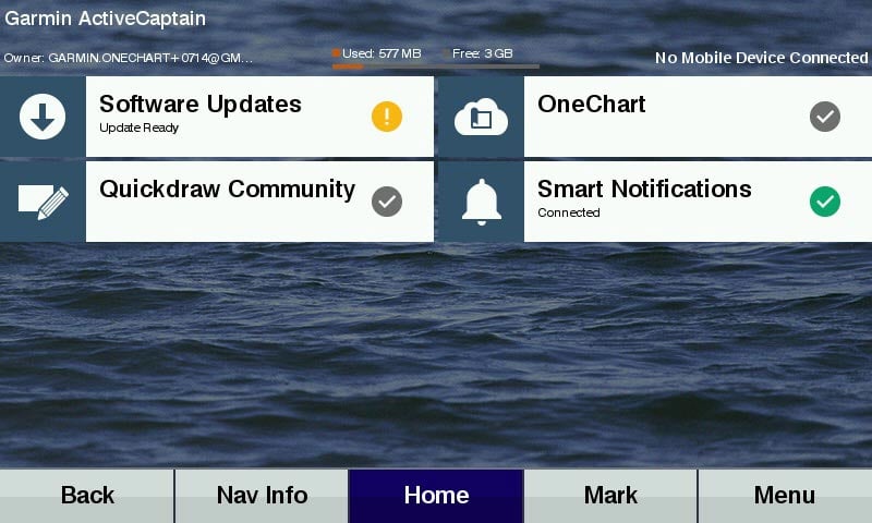
Get Connected with ActiveCaptain App
Our free all-in-one ActiveCaptain app allows you to manage your marine experience from nearly anywhere. It creates a simple yet powerful connection between your compatible mobile device and your chartplotter, charts, maps and the community. Use the combo’s built-in Wi-Fi® to pair with the free ActiveCaptain app for access to OneChart, which allows you to update or purchase and download new charts. ActiveCaptain also gives you access to smart notifications1, the ActiveCaptain community for marina and other points of interest details, Quickdraw Community data and more.
SailAssist Features
SailAssist features include laylines, enhanced wind rose and heading and course-over-ground lines. See true and apparent wind angle and speed as well as set and drift and a glance. To help you gain a wind-maximizing competitive edge, a pre-race guidance page that shows your virtual starting line along with data fields showing laylines, time to burn before the start and a race timer.
Upgrade to Our Best Maps on the Water
Step up to Canada LakeVü HD Ultra with Max Def Lakes, BlueChart® g2 HD or BlueChart® g2 Vision® HD, which adds Auto Guidance1 and other great features. A single microSD™ card slot provides expandable memory for accessory map purchases.
NMEA 2000® Network Support
Provides NMEA 2000 support for engine data, sensors, FUSION-LINK™ audio system, autopilots and more.
Take Your ECHOMAP Plus with You
When you’re off the water, it’s easy to keep your ECHOMAP Plus combo safe and secure. You don’t have to mess with plugging and unplugging wires from the unit because the cords plug directly into the mount. This allows you to quickly install and remove your ECHOMAP Plus from power and the mount.
¹When paired with a compatible mobile device.
²Auto Guidance is for planning purposes only and does not replace safe navigation operations.
Wi-Fi® is a registered trademark of the Wi-Fi Alliance.