

Description
-
- Multi language support : English, Simplified Chinese, Traditional Chinese, Japanese, Korean, Indonesia Bahasa, Malaysia Bahasa, Vietnamese, Burmese, Thai.
- Available in bigger and clearer 6-inch WVGA color, portrait mode display. Offers a keyed interface with dedicated buttons.
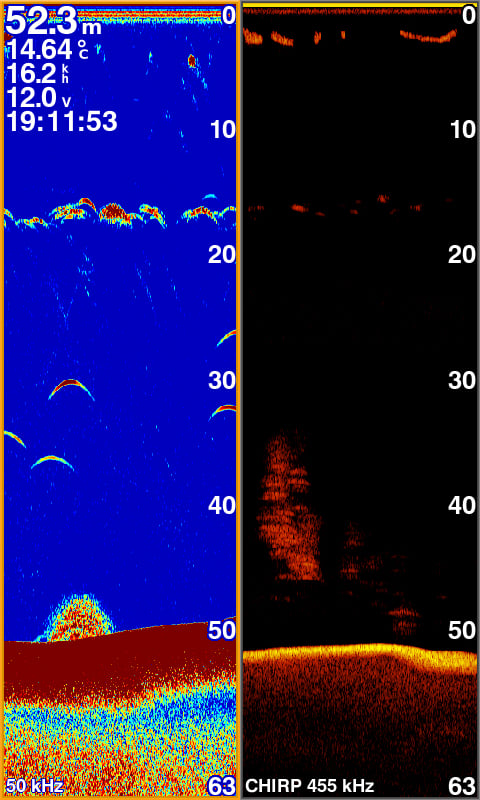
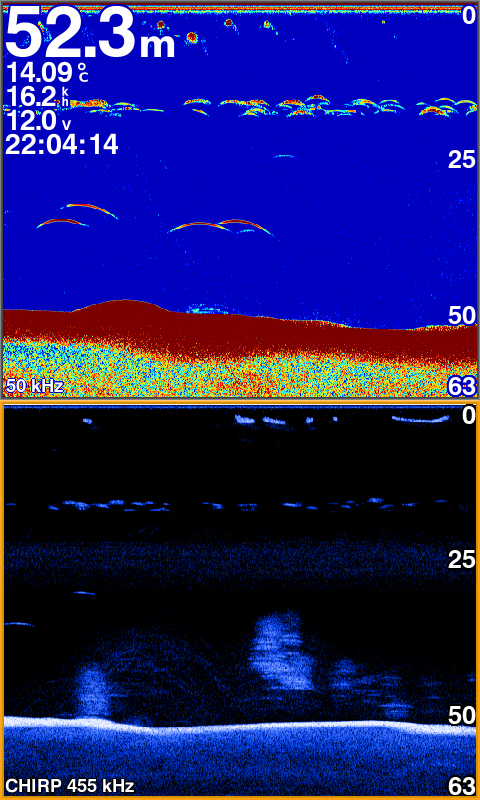
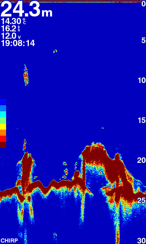
- CHIRP sonar sends a continuous sweep of frequencies ranging from low to high. CHIRP sonar is able to create crisper fish arches with better target separation.
- Built-in 600 W (RMS) CHIRP traditional sonar and CHIRP ClearVü scanning sonar gives a clearer picture of what’s below the boat as a photographic image with representation of objects, structure and fish.
- Compatible with GPS, GLONASS and BeiDou powerful positioning systems what quick and easy to drop up to 12,000 accurate waypoints let you find your way back to your secret fishing hot spots.
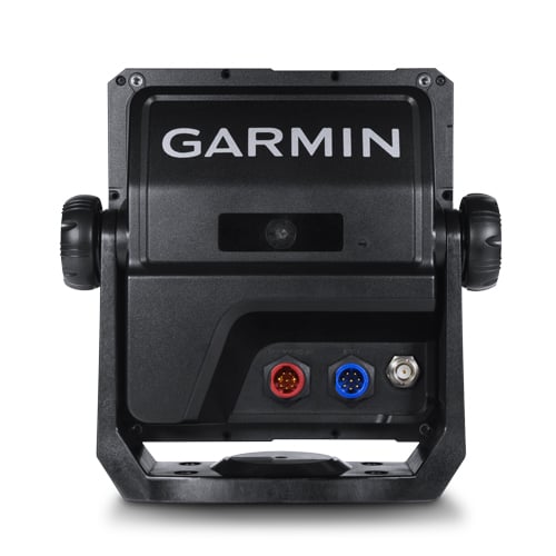
- FF 650 GPS supports for typical NMEA0183 and RS422 communication within 3rd party sensors and accessories.
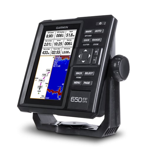
The all-new FF 650 GPS chart plotter / sonar combo is available in 6-inch display and keypad interface. FF 650 GPS is offered to support with Asian multi language and developed the target for semi-commercial fishing market. FF 650 GPS gives you built-in CHIRP traditional sonar and CHIRP ClearVü scanning sonar capabilities which shows crisp fish arches with excellent target separation and provides clear images of structure below the boat. Supporting GPS, GPS + GLONASS, GPS + BEIDOU 3 kind of powerful positioning modes.
The Power of Garmin CHIRP
The built-in sonar capabilities of FF 650 GPS includes CHIRP sonar, the most sophisticated sonar technology available for the fishing and boating public. CHIRP sonar provides amazingly clear target separation and definition because it puts even more energy onto the target than traditional sonar.
Clearest Scanning Sonar on the Water
Garmin CHIRP ClearVü scanning sonar gives you a nearly photographic image down below your boat. Traditional Garmin HD-ID™ sonar and ClearVü scanning sonar are combined into 1 transducer.
Compatible with GPS, GLONASS and BeiDou
With multi positioning modes supports to GPS, GLONASS and BeiDou three powerful systems. It is quick and easy to drop up to 12,000 accurate waypoints and find your way back to your secret fishing hot spots. Huge capacity memory to help fishermen record danger spot(Mark) and the destination(Waypoint).
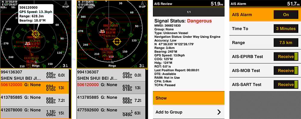
AIS Radar Support
Show you the detailed AIS Radar view and AIS list at the same page. Move the cursor and review particular item on the radar view to see the detail information of highlighted vessel. Drop VRM/EBL and measure distance on the AIS Radar view window and to focus a AIS vessel through the AIS list to see the detail of it.
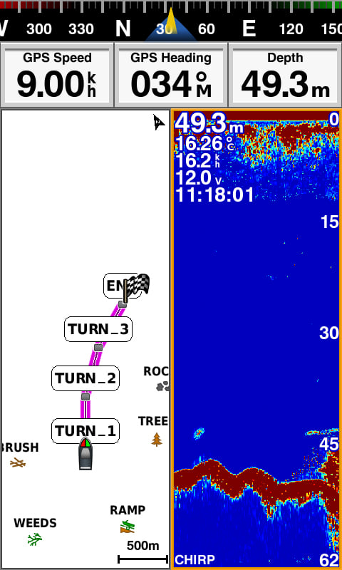
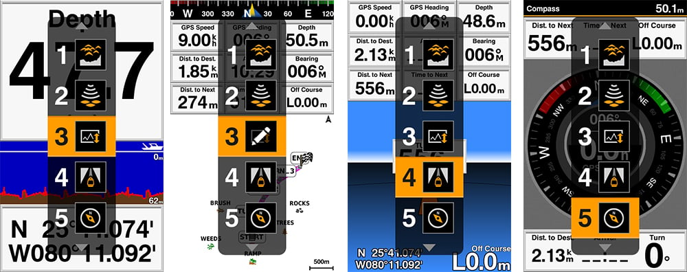
Quick PAGE Sequence
Dedicated PAGE button to have a quick features exchange. Press the “PAGE” button to let user can switch from frequently use feature one by one quickly. With holding the “PAGE” button user can edit their prefer 5 frequently use pages themsleves.
Digital Zoom and Shift Zoom Supporting
Digital Zoom and Shift Zoom features let you control your owned display portion as what you prefer to shows in detailed.
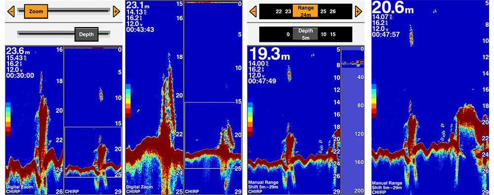
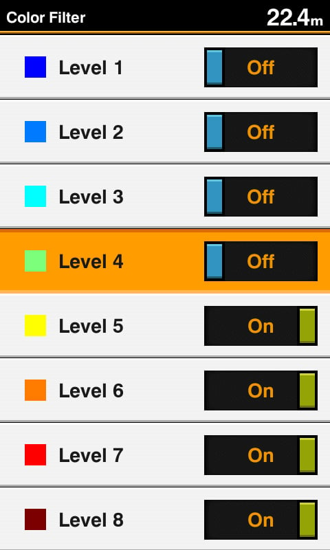
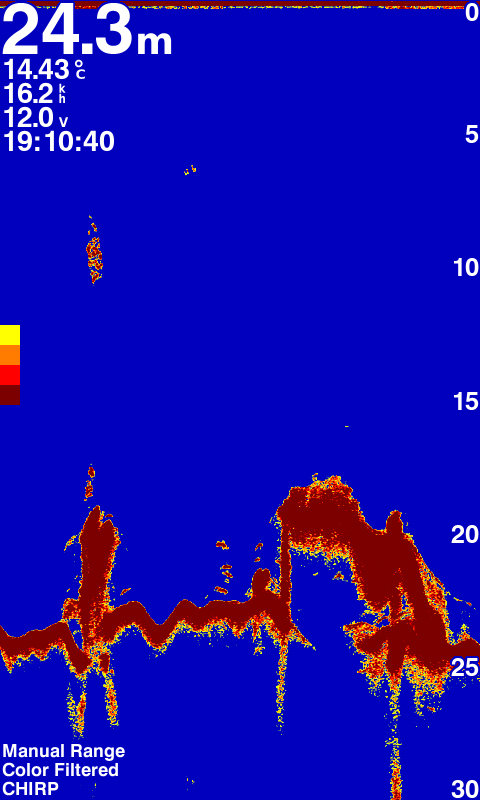
Color Filter for Traditional Sonar Display
8 color levels let users can switch the toggle to turn ON/OFF the specific color on traditional sonar page with their owned preference to show the sonar display.
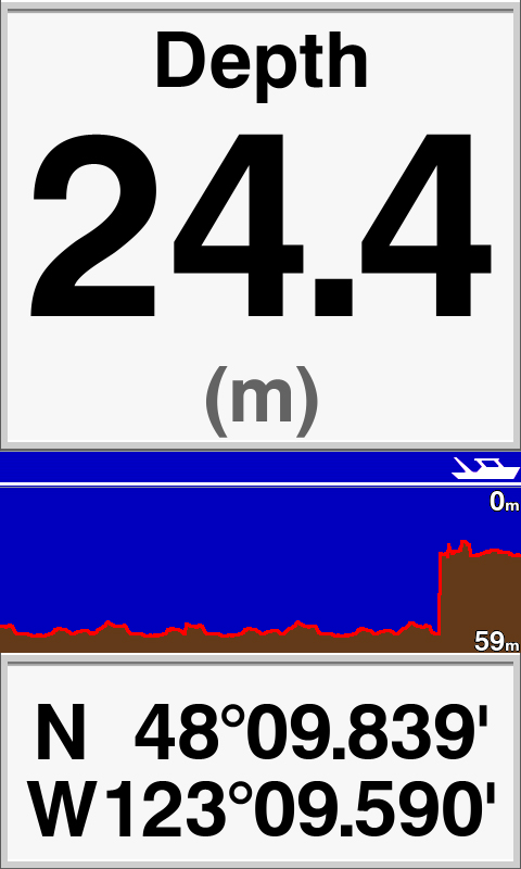
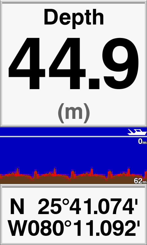
Depth Data Graph
Provides instant value and history logs graph to understand submarine topograpgy and shows you the history of depth data graph at a glance.
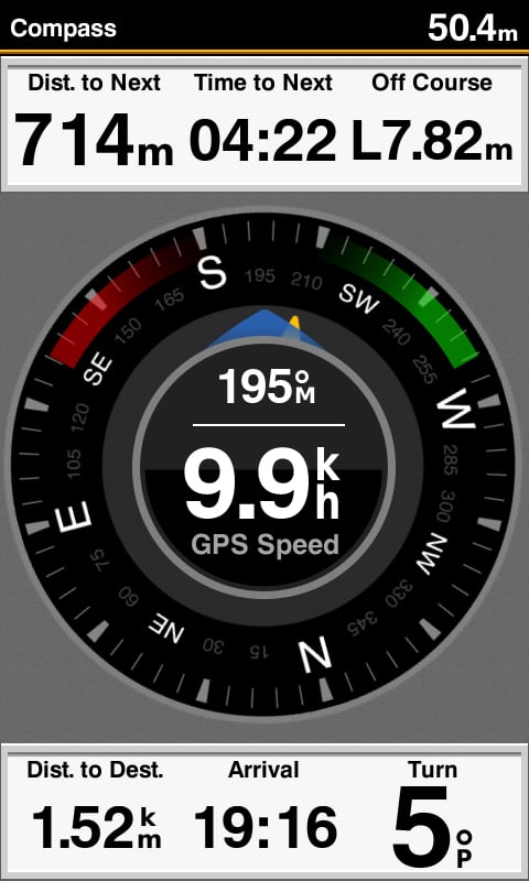
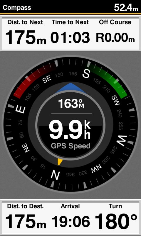
Compass Page to Know COG and SOG at A Glance
Display speed and heading at one page shows to semi-commercial fishermen. They can rely on these information to judge whather the net is full or not while trawling and understand to align the direction of casting the net just at a glanc.
GPX Waypoints Transfer
If you have waypoints, tracks or frequently used routes stored on another manufacturer’s GPS product – or on a Garmin handheld device – now it’s easier than ever to transfer those items to your new Garmin chartplotter, via industry-standard GPX software formatting. GPX is an open standard format for GPS data exchange across platforms and applications. With this easy-to-use interface technology, Garmin has taken “no waypoint left behind” to a whole new level of trade-up convenience.
Cross Products Comparison
FF 350 Plus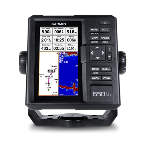
FF 650 GPS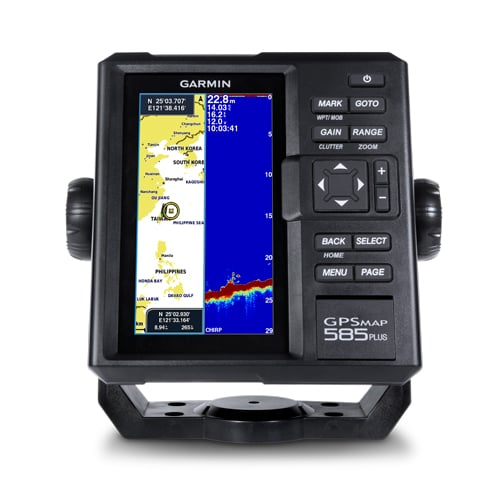
GPSMAP 585 PlusDisplay size 6” color, portrait 6” color, portrait 6” color, portrait Display resolution 480 x 800 480 x 800 480 x 800 GPS/GLONASS/BeiDou • • GPS antenna built-in • • External GPS antenna support • • Sonar output power(RMS) 300W 600W 600W Sonar Frequency 50/77/200kHz 50/77/200kHz CHIRP (Low, Mid, High) 50/77/200kHz CHIRP (Low, Mid, High) ClearVü • • • Scanning sonar frequency 260/455/800kHz CHIRP 260/455/800kHz CHIRP 260/455/800kHz Chart support • (All Garmin Chart/KMZ custom map) Quickdraw™ Contours • Waypoint/Route/Track/Active Track • (12000/200/0 /1) • (12000/200/100/1) IPX7 Waterproof • • • NMEA 0183/RS422 • • SD Card • (2 standard SD) Multi-language support • • •


